
Quaternary Mapping of Areas in Wexford 2020
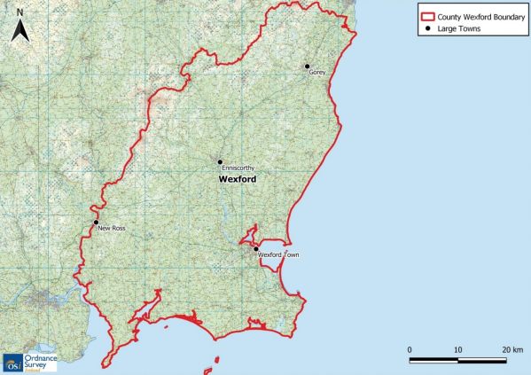
Taking advantage of the extensive and detailed information generated over the course of the Tellus Project, Quaternary mapping will start in July 2020 in rural parts of Co Wexford. The Quaternary geology of Ireland – is an important representation of Irish land showing water sources and various other features important to the development of agriculture.
This survey will involve the use of:
- Shallow geophysical surveys using Ground Penetrating Radar (GPR) and Electrical Resistivity Imaging (ERI) systems. GPR involves dragging the system on the ground to record subsurface discontinuities. ERI measures the subsoil conductivity from electrodes placed on the ground
- Shallow drilling six inches diameter boreholes bored by a drilling rig mounted on a 4-wheel drive lorry. Boreholes are up to 20 m deep and are filled in after drilling.
- Exposure recording consisting of description of shallow sediments exposed at surface and collection of samples to carry out further lab analyses.
The Quaternary geology field programme is gathering outcrop, borehole and shallow geophysical data in areas where existing data coverage is low, to improve the National Quaternary map. A new digital field data collection system has been developed in-house. The map is updated annually after the results of each summer field season have been compiled.
N.B. The Quaternary mapping project is not a commercial mineral exploration programme nor is it related to fracking, pylons or wind-farm development.
Please see our outreach poster here.
Mapping area map.

